Iowa and Its Flora
The Physical Setting
Location
Iowa lies near the center of the continental United States, between approximately 40° 35' and 43° 30' north latitude and between 90° and 96° 30' west longitude, and encompasses an area of 56,290 square miles. It is located between two of the world's principal rivers, being bounded on the east by the Mississippi River and on the west by the Missouri River from the Missouri-Iowa border north to Sioux City. Running north from Sioux City, the Big Sioux River forms the remainder of the state's western boundary.
Climate
The climate of Iowa is characterized as extreme midcontinental (Reed 1941) or as humid continental, warm summer, with a small portion of northern and northeastern Iowa in the cool summer subtype (Espenshade 1964). These climatic types are characterized by warm or occasionally hot summers, with rainfall in the form of showers and thunderstorms. Iowa is subjected to seasonal extremes and frequent rapid local weather changes due to the convergence of cold dry arctic air, moist maritime air from the Gulf of Mexico, and Pacific air masses that have lost their moisture while crossing the Rocky
Mountains. Summers are warm and humid due to the influence of relatively unstable maritime air masses. Hot winds and periods of high temperatures occasionally occur from May to September.
The average annual temperature ranges from 40°F along the northern border to 52°F in the southeast corner (Reed 1941). The mean July maximum temperatures range from 86°F to 90°F, with minima of 60°F to 66°F. The mean January maxima range from 24°F to 34°F, with minima of 4°F to 14°F. Winters are dominated by cold dry air masses from the Arctic, and there may be extended periods of subfreezing temperatures. Winter precipitation is of frontal origin and falls mostly in the form of snow. The lowest temperatures occur in the northern portion of the state, where minima of -20°F to -25°F are not uncommon. In southern Iowa, comparable lows of -10°F to -15°F occur. In the southeast, the January mean is 24°F; in the northwest, it is 13°F.
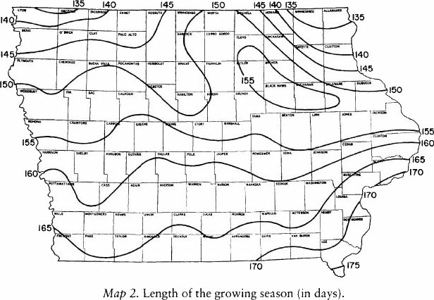
A considerable difference in the length of growing season can be found across Iowa (map 2). The extreme northwestern and northeastern portions average 135 days, which increases to 175 days in southern Lee County (Reed 1941). The statewide average is 158 days, from May 2 to October 7.
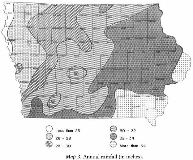
A gentle precipitation gradient exists generally from southeast to northwest (Reed 1941), with an average of over 34 inches in the extreme southeast and east to less than 26 inches in the northwest (map 3). This gradient is of importance in limiting the distribution of numerous plant species. The low rainfall of northwestern Iowa restricts woodlands to stream corridors and to some sparse or shrubby upland areas. The increased available moisture in eastern Iowa permits the growth of upland deciduous forests, an extension of the eastern deciduous forest. These interdigitate with the tallgrass prairie farther west.
About two-thirds of the state's precipitation falls from April to September, with a peak in late spring and early summer. An approximate twenty-year drought cycle occurs in Iowa. It may be of importance in limiting the occurrence of some prairie species and certain northern wetland species and, perhaps, is most critical in restricting woody species. The average annual daytime relative humidity of Iowa is 72 percent, ranging from 69 percent in the southwest to 78 percent in the northeast (Reed 1941).
The preceding factors, working in concert, have subtle but important effects on plant distributions. The longer growing season and high rainfall of southeastern Iowa allow certain southern species to enter that part of the state. On the other hand, the arid conditions of extreme western Iowa allow a number of Great Plains species to enter that part of the state.
Geology
Most of Iowa is underlain by sedimentary rocks such as shales, sandstones, limestones, and dolomites. These are generally deeply buried below glacial deposits and have little influence on plant distribution and abundance. Exceptions are in the northeast, where the bedrock is very near the surface and where many outcrops occur. In the extreme northwest, Sioux Quartzite is at the surface and provides habitat for some unusual plant species. Outcrops also occur along some of the major rivers where these rivers have cut into and exposed the underlying bedrock, such as at Ledges State Park, Boone County; at Dolliver State Park and Woodman Hollow State Preserve, Webster County; at Lacey-Keosauqua State Park on the Des Moines River in Van Buren County; along the Maquoketa River in Jones County; along the Upper Iowa River in Winneshiek County; at Palisades-Kepler State Park on the
Cedar River in Linn County; and at many places along the Mississippi River. These outcrops extend the range of some northern and eastern plant species, especially certain species of ferns.
Glacial History
The influence of glaciers is of great importance in the distribution of Iowa vascular plants. There were repeated periods of ice cover: several in the Pre-Illinoian, followed by the Illinoian and the most recent, the Wisconsinan. The Pre-Illinoian, beginning over 2 million years before present, covered the entire state several times. Thin deposits of at least one of these glacial advances are present on the Paleozoic Plateau in northeastern Iowa. Deposits from this and other Pre-Illinoian advances can be found over the rest of the state but are buried by younger deposits on the Des Moines Lobe and in the Loess Hills. The next period of glacial advance in the state was the Illinoian, which entered from the east, causing an ice block that apparently impounded water in the Iowa-Cedar River basin, resulting in the formation of glacial Lake Calvin. The final Pleistocene event that affected Iowa was the Wisconsinan-age glacier. This last glacial episode occurred about 30,000 to 10,500 years ago. The plants present at that time either migrated south of the glacier or were extirpated. As the glacier retreated, it left a tongue-shaped area terminating at what is now the city of Des Moines. The young landscape is poorly drained and is dotted with lakes and prairie potholes. This final glacial event was followed by the present interglacial stage, when warmer conditions returned and plants were able to become reestablished in central Iowa.
As the glacier retreated or seasonally melted, the meltwater carried sediment in large volume which was deposited on the floodplains of the glacial rivers. When these streams dried at the approach of winter, prevailing westerly winds lifted the fine sediment and deposited it downwind on the Iowa landscape, forming a mantle on the land. This yellowish, flourlike material is termed loess and is today apparent in all except the north-central counties, which were covered by the Wisconsinan glacier at the time of the loess deposits. The hills adjacent to the floodplain of
the Missouri River in far western Iowa, with loess de by its in excess of 150 feet deep in places, are a priceless scenic and biological heritage and are of great importance in plant distribution.
Vegetational History Since the Pleistocene
Iowa was covered by spruce-dominated forests from about 30,000 to 21,500 years ago. These forests were replaced by very open tundra and parkland during the last glacial maximum, about 21,500 to around 16,000 years ago. Spruce forests returned as the climate began to warm from 16,000 to 12,000 years ago, when they, in turn, were replaced by deciduous forests as the warming trend continued (Baker et al. 1990).
Prairies entered western Iowa about 9,000 years ago and extended to central Iowa by 8,500 years ago. The warmest and driest conditions prevailed about 6,300 years ago in western and central Iowa. However, in eastern Iowa, mesic deciduous forest prevailed until 5,500 years ago, when it finally was replaced by prairie. A sharp climatic and vegetational boundary must have extended north-south between eastern and central Iowa between 8,500 and 5,500 years ago, with prairie on the west and mesic forest on the east (Baker et al. 1990).
Between 4,000 and 3,000 years ago, oaks returned and became abundant in the state, apparently in oak savannas. This vegetation persisted until Euro-American settlers arrived (Baker et al. 1992).
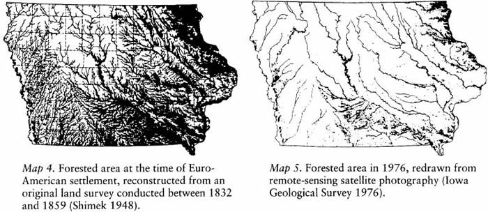
Prairie fires, set by lightning and possibly by early Native Americans, retarded the advance of the forest and kept the prairie areas treeless. Evidence of the effectiveness of prairie fires comes from studies (e.g., McComb and Loomis 1944) showing forest-derived soils occurring principally on the eastern sides of streams, which provided breaks against the fires driven by the prevailing westerly winds. At the time of Euro-American settlement, approximately 85 percent of the state was covered by prairie (map 4; State Planning Board 1925). Extant prairies, when compared with photographs of the same sites from early in this century, show a great increase in forest invasion. Wetlands protected bur oak knobs from frequent fires; thus, these areas became savannas, of which degraded examples still exist. Today the prairie has been reduced to approximately 0.01 percent of its extent at the time of Euro-American settlement, the woodlands have decreased to about one-fourth of their former area (map 5; Thomson and Hertel 1981), and the wetlands have declined from around 1.5 million acres to perhaps as few as 27,000 acres (Bishop 1981). (This latter figure does not include sedge meadows, fens, or wet prairies.)
The Natural Regions of Iowa
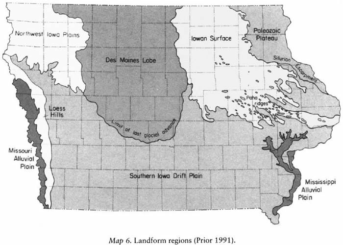
As a result of the preceding factors, Iowa has a landscape which can be divided into biogeo-graphical provinces or natural regions. These are shown in map 6 and are described in terms of their influence on the distribution of plants in Iowa. The regions were discussed in Prior (1991) and are expanded upon here to include additional information of a botanical nature.
Paleozoic Plateau
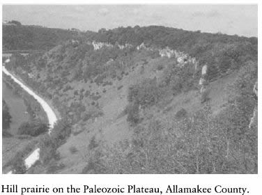
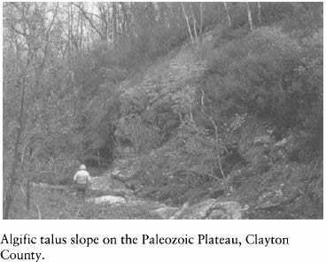
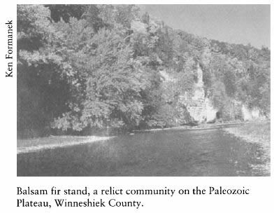
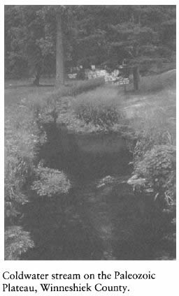
The Paleozoic Plateau in northeast Iowa is the most rugged part of the state and is often referred to as Little Switzerland. It is divided from the remainder of the state by the Silurian Escarpment. Deep valleys provide a variety of microhabitats that are necessary for the existence of many species of plants on the margins of their ranges. This portion of Iowa is of vital concern to botanists interested in the Iowa vascular plant flora because it contains many boreal species, disjuncts, and endangered or threatened species.
The Paleozoic Plateau occurs in the part of the state historically called the Driftless Area. It is a portion of a much larger multistate area of approximately 15,000 square miles. The majority of this area lies in Wisconsin, with smaller areas in Illinois, Iowa, and Minnesota. It is known to have escaped coverage during the Illinoian and Wisconsinan glacial advances into the upper Midwest and perhaps served as a refugium for plants during this time. In Iowa, the Paleozoic Plateau consists of an area of some 1,050 square miles, including portions of Allamakee, Clayton, Delaware, Dubuque, Howard, Jackson, and Winneshiek counties. Important references to this landform region are Hartley (1966), Cahayla-Wynne and Glenn-Lewin (1978), Peck (1982), Peck, Roosa, and Eilers (1980), and a special issue of the Proceedings of the Iowa Academy of Science (vol. 91, no. 1) devoted to the natural history of the Driftless Area.
Cliff-dwelling Plants
Bedrock controls the landscape of the Paleozoic Plateau and often outcrops to provide habitat for cliff-dwelling species such as:
Algific Talus Slope Plants
The north-facing, moss-covered talus slopes, with continuous cold air drainage, form habitat for a variety of plants, some of which are among Iowa's rarest. These slopes have recently been termed "algific talus slopes" by Frest (1981) and are briefly described by Glenn-Lewin, Laushman, and Whitson (1984) and Hartley (1966).
Plants characteristic of this community include:
Plants of Cold, Spring-fed Streams
The following species occur in or along spring-fed streams mostly found in northeastern Iowa:
Disjunct Populations
Populations which are disjunct from the more northern main portion of their ranges are found in the Paleozoic Plateau, including:
Very Rare Species
The only known Iowa stations for the following species are found in the Paleozoic Plateau:
Despite extensive plant collecting in this landform region in the past, new discoveries continue to occur. For example, the first Iowa stations for Aureolaria pedicularia, Botrycbium matricariifolium, Conopholis americana, Dryopteris X boottii, Hepatica nobilis var. obtusa, Pyrola asarifolia, Spiranthes lucida, and Viola adunca were discovered here in recent years.
Hill Prairies
Relatively extensive hill prairies, described by Hartley (1966) and Ugarte (1987), are also in the Paleozoic Plateau. These were historically kept treeless by drying winds, fires, and very thin topsoil. Characteristic species include:
Oak-Juniper Glades
Hartley (1966) described juniper glades on the bluffs of the Mississippi River; Glenn-Lewin, Laushman, and Whitson (1984) called them oak-juniper glades and described them as assemblages of xerophytic species on dry, exposed, calcareous crags, cliffs, and bluffs having thin soil. These are dominated by:
Sandy Areas
Sandy wooded slopes, sand plains, and sand terraces occur in the northern portion of the Paleozoic Plateau. Sandy wooded slopes are present in Allamakee County along Bear Creek, Village Creek, and Yellow River. Plants normally associated with sandy areas include:
Sand plains can be found in northern Allamakee County along the Upper Iowa River and are a result of deposition by the river during the Pleistocene epoch. These are naturally nearly barren, but extensive pine planting has taken place on some. Plants characteristic of this habitat include:
Sand terraces occur in Allamakee County along the Mississippi and Upper Iowa rivers. Some plants principally restricted to this habitat are:
Upland Woods
Upland woods in the Paleozoic Plateau were described by Hartley (1966) and by Cahayla-Wynne and Glenn-Lewin (1978). These woods exist in upland regions where the covering of loess soil still remains and may be very dry, dominated by oak and hickory. On deeper soils and protected slopes, the community may be mesic and may include such species as black walnut, red oak, hard maple, and basswood. Some characteristic species include:
Dry Sandstone Ledges and Talus
In the northern portion of the Paleozoic Plateau, in northern Allamakee and Winneshiek counties, are outcrops of dry sandstone, including the soft St. Peter sandstone. Among the characteristic or rare taxa here are:
Moist Limestone Ledges and Cliffs
Found in Allamakee, Clayton, Delaware, Dubuque, Fayette, and Winneshiek counties are moist limestone ledges and cliffs which support the following species:
Iowan Surface
The Iowan Surface is a large landform region bounded on the east by the Niagaran Escarpment, on the south by the Southern Iowa Drift Plain, and on the west by the Des Moines Lobe. This landform encompasses all, or nearly all, of twenty-seven counties in northeastern Iowa. This region is somewhat tongue-shaped, with the long axis oriented in a north-northwest to south-southeast direction. The southern terminus is deeply lobed, the protrusions being upland areas between the valleys of the large rivers and streams (Eilers 1971).
The bedrock underlying the Iowan Surface dips from the northeast to southwest. The oldest system, the Silurian, outcrops as Niagaran dolomite along streams in Clayton, Jones, Cedar, and Fayette counties. Outcrops of Pennsylvanian sandstone along the Iowa River near Eldora are of interest because of the flora they support.
A prominent feature of the southern portion of the Iowan Surface are the paha, which are loess-capped knobs and ridges oriented west-northwest to east-southeast. These rise 50 feet or more above the existing landscape and have a nucleus of Pre-Illinoian (Kansan) till (Scholtes 1955). The most prominent paha are covered by oak-hickory woods.
The Iowan Surface is a botanically varied landscape, with plant communities such as wetlands, tallgrass prairie, loess-capped paha, fens, streams with submerged aquatic plants, and sand deposits. An important botanical reference to this erosional surface is Eilers (1971).
Wetlands
Wetlands, now often with stands of trembling aspen {Populus tremuloides), are of botanical interest because they provide an organically rich, usually moist humus for certain plants that need an acidic substrate. Species in this habitat include:
Fens
Throughout the Iowan Surface exists a special type of wetland or peatland which has developed in mineral-rich water. These are termed fens and may occur on hillsides where erosion has exposed a discharge area, where water is carried laterally through gravel deposits and discharges on the slope. Fens may occur on any portion of the slope face or as a mounded peat deposit on the nearly level ground in the drainageway. The latter type has long been called mound springs but differs little in its flora from other fens. Another peatland with a different developmental history is the type which develops in abandoned stream channels and undergoes succession through the centuries from an open-water habitat to a sedge mat with attendant peat deposition. Two classic examples of this type of peatland occur on the Iowan Surface: the renowned Buffalo Slough in Cerro Gordo County and Cutshall Access in Buchanan County. A complex of plant species, including the following, seems to be principally restricted to these two peatland types:
Sandy Areas
Extensive sandy areas exist on the Iowan Surface, particularly along the Cedar and Wapsipinicon rivers. These are mostly eolian deposits and may contain deflation basins and dunes, but most such dunes have been stabilized by vegetation. Some taxa which are principally restricted to these sandy areas include:
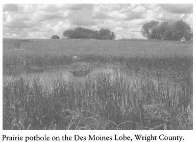
Des Moines Lobe
The youngest landform region in Iowa is the Des Moines Lobe, a tongue-shaped area of approximately 12,000 square miles. It terminates at the city of Des Moines at the confluence of the Des Moines and Raccoon rivers. The Raccoon River forms the southern and western border of the lobe. This landform is poorly drained and is
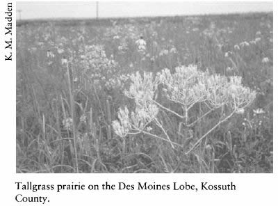
dotted with potholes, particularly in the northwestern portion. Glacial moraines form prominent features as, for example, Ocheyedan Mound in Osceola County, Pilot Knob in Hancock County, and Pilot Mound in Boone County. Large, open-water lakes such as Spirit Lake and Lake Okoboji in Dickinson County, Clear Lake in Cerro Gordo County, and Storm Lake in Buena Vista County are scattered throughout the landscape.
The Des Moines Lobe once supported a prime example of the tallgass prairie biome, which has since been almost completely converted to agricultural crops. Nonetheless, this region contains some of Iowa's finest remnants of the tallgrass prairie. Lespedeza leptostachya, a plant endemic to the upper Midwest, is found on some of these remnants.
Savannas
In the northern part of the lobe, glacial knobs and ridges were partially or wholly surrounded by shallow marshes. The wetlands protected the ridges from frequent prairie fires and promoted the establishment of savannas. These are especially noticeable in the region of Pilot Knob State Preserve.
Peatlands
The Des Moines Lobe contained many peatlands and Carex swales. The peatlands contained Drepanocladus moss, unlike those of the more northern parts of the United States
which are largely composed of Sphagnum. However, in this part of the lobe is found the state's only example of a Sphagnum bog (called by some researchers a "nutrient-poor fen" or "poor fen"), existing in Pilot Knob State Preserve. Recent palynological evidence indicates that this bog has been present since before Euro-American settlement and is probably a relict from conditions which prevailed at the end of the Pleistocene (R. Baker, personal communication). Somehow it escaped recognition until 1954 (Grant and Thorne 1955). A number of rare taxa, such as the following, are found on the floating mat:
In parts of the lobe are prominent end moraines which are dry and often gravelly. In central Iowa, good examples are found in the area of southwestern Wright County, southeastern Franklin County, and portions of Boone County. In the northwestern portion of the lobe, good examples of the characteristic swell and swale topography are found in the region of Lake Okoboji. Associated with this landscape are depressions termed kettleholes, where chunks of ice were covered by glacial till. As the glaciers melted, they left the concentric, cone-shaped kettleholes. One of the best examples of these is the Freda Haffner Kettlehole near Lake Okoboji. The plants of this preserve have recently been studied (Freese and Piatt 1991). In close proximity to the potholes and marshes are found knobs and ridges caused by the relatively recent glacial activity.
Dry Knobs
On dry knobs are found, for example:
Land-use practices are causing dry knobs to be highly modified, with some being mined for gravel.
Wet Depressions
In wet depressions are found an array of marsh plants. Most are at or near the southern terminus of their ranges and include:
Fens
Fens are at or near the interface of the Des Moines Lobe and the older glacial surface to the west. Silver Lake Fen has long been state-owned; several other complexes have recently been acquired by the Nature Conservancy or Department of Natural Resources.
The northwestern portion of the Des Moines Lobe was thought until recently to be the only part of Iowa where fens existed. These fens have been studied by botanists for over a hundred years. Although similar in many respects to the fens on the Iowan Surface, some important differences exist. Des Moines Lobe fens are more likely to have a deposit of tufa (calcareous or siliceous rock deposits of springs or groundwater) at the surface; Des Moines Lobe fens are divided into distinctive vegetative zones; ferns do not normally occur on Des Moines Lobe fens, while Iowan Surface fens are much more likely to have trees and shrubs. Three rare shrubs, Betula pumila var. glandulifera, Salix Candida, and S. pedicellaris, are not found on Des Moines Lobe fens.
Plants principally restricted to Des Moines Lobe fens include:
Northwest Iowa Plains
The Northwest Iowa Plains region is a largely treeless, gently rolling area that has the highest altitude and lowest rainfall in the state. Relief in this region is low, on the order of 10 to 30 feet. Because of this low relief, the region has been almost entirely converted to agricultural uses. This landform region is bordered on the west by the Big Sioux River, on the east by the Des Moines Lobe, and on the south by the Southern Iowa Drift Plain.
The area is not very well known botanically, as some of it fell between Carter's (1960) study of northwestern Iowa and Monson's (1959) study of the Des Moines Lobe. Hayden (1943) includes part of this section in her lakes area study. Native tallgrass prairie remnants are still found here but not in the abundance found by Hayden (1946). The upper reaches of the Little Sioux River provide the major source of drainage.
The western portion of this landform is of importance as habitat for Great Plains plant species and relict prairie areas. Peck et al. (1984) summarized and updated the flora of Lyon and Sioux counties.
Gravel Hills
The following uncommon species occur on the loess-capped or gravel hills along the Big Sioux River:
Gravel Bluffs and Ridges
Extensive dry gravel bluffs and ridges along streams, especially in Cherokee and O'Brien counties, provide habitat for plants generally found farther west. Examples are:
Sioux Quartzite Outcrops
A small, anomalous area occurs in the very northwestern part of the region. It is an outcrop of an ancient bedrock known as Sioux Quartzite. This is a pink to reddish stone dated at around 1.2 billion years before present. On the thin soil which covers portions of the quartzite, xeric conditions prevail, making excellent habitat for a number of rare species. Vernal pools on the edges of an old quarry provide another habitat for some rare taxa. Shimek (1896) and Vander Zee (1979) are important botanical references to this area. Taxa of restricted distribution in Iowa which occur in this habitat include:
Southern Iowa Drift Plain
Most of the southern half of Iowa was last glaciated by the Pre-Illinoian glacier, approximately 600,000 years ago. This part of Iowa is a mature landscape, historically fairly heavily wooded. Today, the central portion still contains
a significant proportion of Iowa's remaining woodlands.
Subtle changes in the landscape occur across this large area. The eastern portion is characterized by tabular uplands, which disappear as one travels westward. Loess mantles the entire area, decreasing from a thick blanket in the west to a thin layer on the flat uplands in the east. Through processes of erosion throughout the centuries, evidence of moraines or marshes has been lost.
Western Portion
The western portion of the Southern Iowa Drift Plain, exclusive of the Loess Hills, is relatively treeless. The tabular uplands have disappeared, and rolling uplands and broad valleys are characteristic. An important botanical reference to this landform region is Fay (1953). Probably no plant species are confined to this section, but the following are of restricted distribution in the state and are the most common here:
Central Portion
The landscape of the central portion of the Southern Iowa Drift Plain differs from that to the east by the near absence of flat uplands and a much more rolling character. It differs from that to the west by being more heavily forested, the loess mantle being thinner and the uplands more marked. An important botanical reference for this part of the landform is Van Bruggen (1958).
Perhaps no plant species are confined to this section, but the following are characteristic or occur here as their principal Iowa range:
Eastern Portion
The eastern portion of the Southern Iowa Drift Plain is a large, fairly homogeneous area characterized by tabular uplands, with steep topography only along streams. Little forest cover remains, except in areas owned by the state of Iowa. Plant species restricted to this part of Iowa include:
The extreme eastern extension of the Southern Iowa Drift Plain is a rugged part of Iowa and is replete with flat uplands historically covered by prairie species, with scenic entrenched rivers, wooded ravines, and many rock outcrops. It is of importance botanically, and much of it was surveyed by Cooperrider (1962). In places, the Maquoketa River valley is a deep gorge with outcrops that provide habitats for many cliff-dwelling species normally found farther north. In recent years, algific talus slopes have been discovered in this portion of the Southern Iowa Drift Plain, and numerous plants have been documented farther south than previously suspected. Examples of these and other plants which have a narrow ecological tolerance include:
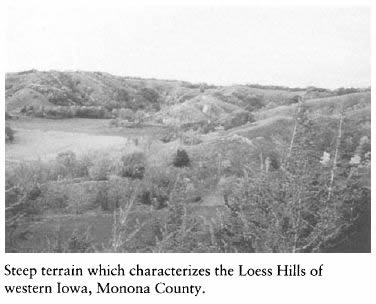
Loess Hills
Along the western edge of Iowa, a relatively narrow tract of deep deposits of wind-deposited loess parallels the floodplain of the Missouri River. These spectacular hillssteep, west-facing, and dryare of singular biological significance for Iowa. Before Euro-American settlement, they were nearly treeless due to intermittent fires and extreme climatic conditions caused by exposure to drying winds and the hot afternoon sun. Great Plains plant species find suitable habitat in this landform region, and here the bulk of Iowa's remnant prairies remain. Important references to the Loess Hills of Iowa are Mutel (1991), two special issues of the Proceedings of the Iowa Academy of Science (vol. 92, no. 5, and vol. 93, no. 2), and Novacek, Roosa, and Pusateri (1983).
On the dry slopes and hilltops are found the following:
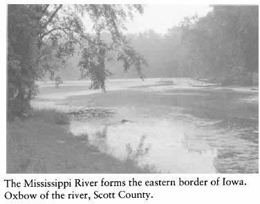
Missouri River Alluvium Region
For centuries the Missouri River occupied a large floodplain, periodically flooding, changing course, and creating oxbows and annually depositing a layer of silt. Only recently has the river been channelized, straightened, diked, and "controlled." Now nearly entirely converted to agricultural uses, this floodplain once had extensive stands of low prairie species. Sand dune areas also exist in the floodplain, most with extensive growths of woody species. Many of these species became "stabilized," because a 1952 flood deposited a layer of silt that made it possible for succession to occur.
Oxbows
Remaining oxbows of the Missouri River contain a diverse array of aquatic species, including:
Sand Dunes
Dry sand dunes are found near the Missouri River, especially in Harrison, Monona, and Woodbury counties. Although these are rapidly being overgrown by woody species, they still support a variety of plants, most of which are restricted to this habitat. These include:
Riverine Systems
A Riverine System region was not recognized by Prior (1991) as a discrete landform because these corridors are part of each of the described landforms. The floodplains along streams contam
what is perhaps the state's most endangered communitythe floodplain forest. Because of the flat, rich character of this landform, most of it has been heavily logged, cleared for pastureland, or converted to agricultural use. In the valleys in the southeastern part of Iowa, an Ozarkian floristic element is apparent. In the wooded floodplains are found the following unusual or characteristic species which have migrated northward from the Ozark plateau:
Sand Provinces
Areas of pure sand occur along major rivers, principally the Mississippi, Cedar, and Wapsipinicon in eastern Iowa and along the Missouri River in western Iowa. Some of Iowa's rarest plants live in these sandy areas. Characteristic plants include:
Iowa still has a great diversity of native plant habitats containing many interesting and important species. Efforts are under way by state agencies and by private organizations to preserve as many representative native habitats as is possible. Unfortunately, these groups must work with limited resources. Thus, it is vitally important that each of us contribute what time and money we can to help the efforts succeed.
Origins of the Iowa Flora
Because of the midcontinental location of Iowa, its flora has affinities with the eastern deciduous forests, the boreal flora, the Great Plains prairies, and the Ozarkian woodlands. This makes Iowa a rewarding place to study phyto-geography. Some of the elements that influence the state's total flora are given below.
Plants with Northern Affinities
Several regions of Iowa provide microhabitats similar to those somewhat farther north. Plants that are normally found in more northern latitudes often occur in these microhabitats. Habitats which harbor plants with northern affinities include the fens of the northwestern part of the Des Moines Lobe and the Iowan Surface; the cool, mossy, north-facing slopes of the Paleozoic
Plateau of northeastern Iowa; and the wetlands of northern Iowa. Some of the plants at or near the southern terminus of their ranges are:
Eastern Deciduous Forests
In eastern Iowa occurs the western terminus of the Eastern Deciduous Forest biome. Plant species near the end of their range in this area are:
Oak-Hickory Forest Region
The Oak-Hickory Association is centered on the Ozark Plateau and has spread from that refugium in postglacial times (Braun 1950; Curtis 1959) along protected corridors to southeastern and south-central Iowa and adjacent areas. The Mississippi and Missouri rivers and their tributaries acted as important migrational pathways. However, the existence of ecotypes and subspecies of Ozarkian species in Iowa is evidence that Iowa's oak-hickory forests have been separated from those in the Ozarks for a long enough time for evolutionary differentiation to occur.
Representative species of the Oak-Hickory Association in the upland woods are:
In the more mesic sites of the Oak-Hickory Association, the following occur:
The lowland forests of Iowa can be found on alluvial soil, on the lower slopes of river valleys, and to a lesser extent on the old lake bed of glacial Lake Calvin. Representative species include:
The following plants usually occur on well-drained terraces above the floodplain:
Great Plains Species
Certain Great Plains species enter western Iowa where suitable growing conditions are found, especially on the dry blufftops and west-facing slopes of the Loess Hills. These include: